


Air pollution and health in East Oakland
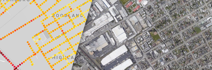
EDF deployed Google Street View cars equipped with Aclima's environmental sensing platform to collect data in a 6 square mile area in the easternmost part of Oakland for a year between 2015 and 2016. The resulting map shows elevated levels of air pollution in many parts of East Oakland.
Air quality data from Google/Aclima; analysis by Apte et al / EDF. Colors on the map do not correlate to colors on the Air Quality Index.
From the map, you can see that I-880 (Nimitz Freeway), a major transportation route serving the Port of Oakland and Oakland International Airport, features significantly higher levels of air pollution. Not surprising, when considering that the I-880 corridor carries the greatest volume of truck traffic [PDF] in the Bay Area region and among any highway in California. The stretch of I-880 shown here sees on average 200,000 vehicle trips per day [PDF].
Other areas of East Oakland with elevated levels of pollution include the busy road corridors shown below, where a number of commercial and industrial facilities are close to residential areas and public spaces. Our map echoes the findings in a 2010 community-based participatory research study [PDF]by Communities for a Better Environment, which found high levels of air pollution along the same roadway, with measurements higher than state and federal standards. The study area is densely populated and includes many places where vulnerable populations gather [PDF], such as schools, senior centers and hospitals, as shown in a 2008 baseline by CBE.
East Oakland's freight corridor, busy roadways and industrial sector have contributed to elevated levels of air pollution, and residents experience some of the highest asthma hospitalization rates compared to the rest of the region, according to a 2016 report by Alameda County Public Health Department.
In an effort to better understand how changes in pollution levels within even small areas could impact health, EDF partnered with Kaiser Permanente and combined our mapping data with electronic health records. We found in a 2018 study that differences in air pollution within neighborhoods or even city blocks can increase risks of heart attack and deaths from heart disease in the elderly.
As in West Oakland, a large percentage of the communities in East Oakland are both low-income and of color. These individuals and families bear a disproportionate burden of environmental impact, resulting in worse health outcomes. East Oakland has higher death rates due to heart disease, stroke and lung cancer than both Oakland and Alameda County. And life expectancy in East Oakland is seven years shorter than the more affluent residents in the Northern area of the city. (Alameda County Public Health 2016 report) While these health outcomes are related to multiple factors, studies have shown that exposure to high levels of air pollution -- from motor vehicles, refineries and other sources -- increases death rates associated with coronary and lung diseases. Our findings, coupled with existing research, highlight the need for stricter regulations to protect the health of communities most impacted by poor air quality.
You can help: Make your voice heard!
Everyone deserves to breathe clean air, and you can make a difference by advocating for common-sense solutions to reduce levels of harmful air pollution.
-
If you live in Oakland, connect with local groups like Communities for a Better Environment, which can help you take action on issues that affect your health and environment.
-
Find a clean air advocacy group working near you. For example, Moms Clean Air Force, a national group of more than a million parents, organizes communities to protect clean air and our kids' health in 20 states.