


How this data method is different
EDF and Google Earth Outreach gain new insight with mobile sensors
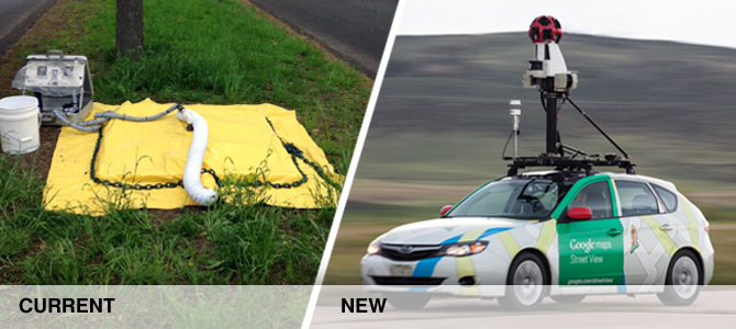
Methane concentration is often measured using enclosures (pictured) or technicians walking with methane “sniffers.”
Utility companies and scientists routinely monitor pipe systems for methane leaks because methane is the primary component of natural gas. The measurement techniques are labor-intensive and time-consuming, but accurately determine atmospheric methane concentrations, the key measurement for determining if leaks are a safety hazard.
But leaks can also have a big impact on the climate, and current monitoring methods don't assess that impact because they don't determine the rate of the leak. So EDF, Google Earth Outreach and researchers at Colorado State University developed a new way to locate and estimate the climate impact of methane leaks. This new method and its results have been published in two peer-reviewed papers for the Environmental Science & Technology journal in March 2017 and September 2018. The result is a method that can quickly identify leaks and their emissions across entire cities. It supplements existing high-precision methods by making the climate effects of local leaks visual and accessible.
What sets this new method apart?
- How we collect data: In this pilot project, we used four specially-equipped Google Street View cars, taking readings across large areas in just a few weeks.
- What we measure: Methane concentration, wind direction and speed, and GPS location. Data was recorded two times a second, and streets were driven multiple times to verify readings.
- What we calculate: Leak rate, so we can estimate the climate impact of a leak as well as its location.
- How we calculate it: Our research team developed a new algorithm that uses intensive calculations and validated it against leaks that utilities already monitor. The analysis has been published in Environmental Science and Technology.
- Where we collect data: In large cities, it is impractical to map every street. To get a representative sample we select areas to drive with a variety of landscapes, type of pipe materials, and pipe ages.
Follow this project
Sign up to hear about our progress and opportunities to help reduce the harm methane does to our climate.

 Contact
 Joe von Fischer