These pollution-spotting satellites are just a taste of what's to come
The most advanced satellite to ever launch from Africa will soon be patrolling South Africa's coastal waters to crack down on oil spills and illegal dumping.
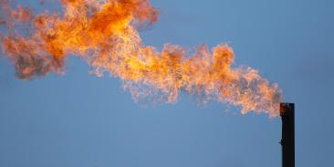
Data from another satellite, this one collecting images from the Texas portion of a sprawling oil and gas region known as the Permian Basin, recently delivered shocking news: Operators there are burning off nearly twice as much natural gas as they've been reporting to state officials.
With some 5,000 satellites now orbiting our planet on any given day, a growing number of images captured from space are shedding new light on the world's mounting environmental challenges. It helps explain why organizations and corporations are beginning to use satellites to track deforestation, pinpoint methane leaks and show impacts of climate change.
What we're looking at here is, of course, just the beginning.
As countries such as Brazil and Indonesia seek to reduce deforestation, and nations like Mexico try to rein in emissions from oil and gas production, satellites will become indispensable. They will help create a constantly innovating industry that will revolutionize environmental monitoring of our planet and hold polluters accountable.
Data shed new light on Texas gas problem
Satellites provide the geographical scope and precision needed to identify and assess problem areas that were previously unknown or poorly measured. Importantly, they will be able to measure changes on land, in oceans and in the air over time.
Thanks to satellites, we now have that actionable data on pollution from oil and natural gas wells that contribute to greenhouse gas emissions at a time when we must act quickly to curb climate change.
A recent study by Environmental Defense Fund focused on natural gas flares from the wells in the Permian Basin, located in Western Texas and southeastern New Mexico. Our analysis proved that the region's pollution problem was much larger than companies had revealed.
A second study about offshore gas flaring in the Gulf of Mexico, published by a group of scientists in the Geophysical Research Letters, showed that operators there burn off a whopping 40% of the natural gas they produce.
And that's not all.
Methane-probing satellite takes off soon
Soon a new satellite will be launching that is specifically designed not just to locate, but accurately measure methane emissions from human-made sources, starting with the global oil and gas industry.
MethaneSAT, a new EDF affiliate unveiled last year, will launch a future where sensors in space will find and measure pollution that today goes undetected. This compact orbital platform will map and quantify methane emissions from oil and gas operations almost anywhere on the planet at least weekly.
The data MethaneSAT collects will help companies and countries identify emission sources, see opportunities to reduce them, and track those reductions over time. The data will be available to the public at no cost, so that we all can make sure both industry and governments are getting the job done.
That is the promise of satellite technology and what we call the Fourth Wave of environmentalism: It reveals, measures, monitors and motivates.
Get innovation updates
We'll send regular updates about developments in technology, science and the environment.


